Hi All,
I realized that it's been awhile so I thought I'd jump in and give you an update of sorts. It's been a whirlwind of ups and downs as cabin fever sets in and things seem to be not working at times.
First, here's the progress on my Worldographer map.
I know, you're probably asking yourself "isn't this the same exact map he showed last time?" Yes and no. I went for the full map being delineated by the smallest hex size I wanted to use. So each hex generated by the program is 6 miles across. All of the coastlines and rivers are done as polygons to get the shapes I wanted. You can see I've put in the border of Monfel in the upper Left area. It more or less follows the area of the hexes from the hand drawn map.
Once I get in more of the borders and settlement I can start tweaking the boundaries and terrain. For instance I need a lot more tributaries for those rivers.
I've been running into a weird issue where I seem to be overloading the program and it will tell me I'm out of memory. I can't save of export or anything. Closing and restarting seems to fix it, so I just try to save my work often.
3d Printing has been going apace. I had a lot of trouble transitioning to the glass bed. It turned out that I needed to lower my bed temperature from 50C to 40C and use glue stick to get prints that didn't come off in the middle of the print, not stick altogether or warp horribly as the layers cooled at different rates. I also adjust some parameters of when the cooling fan came on, but I think bed temp was more important. The main thing is, there is a ton of advice out there and you have to be willing to try different things to find what works for you. Just because other people say xyz works for them it may not work for you.
One of the things I did was print some upgrades for my Ender 3. I found all of them on thingiverse here.
The vent fan cover redirects the airflow so it is not going straight up at the bottom of the left side of the bed.
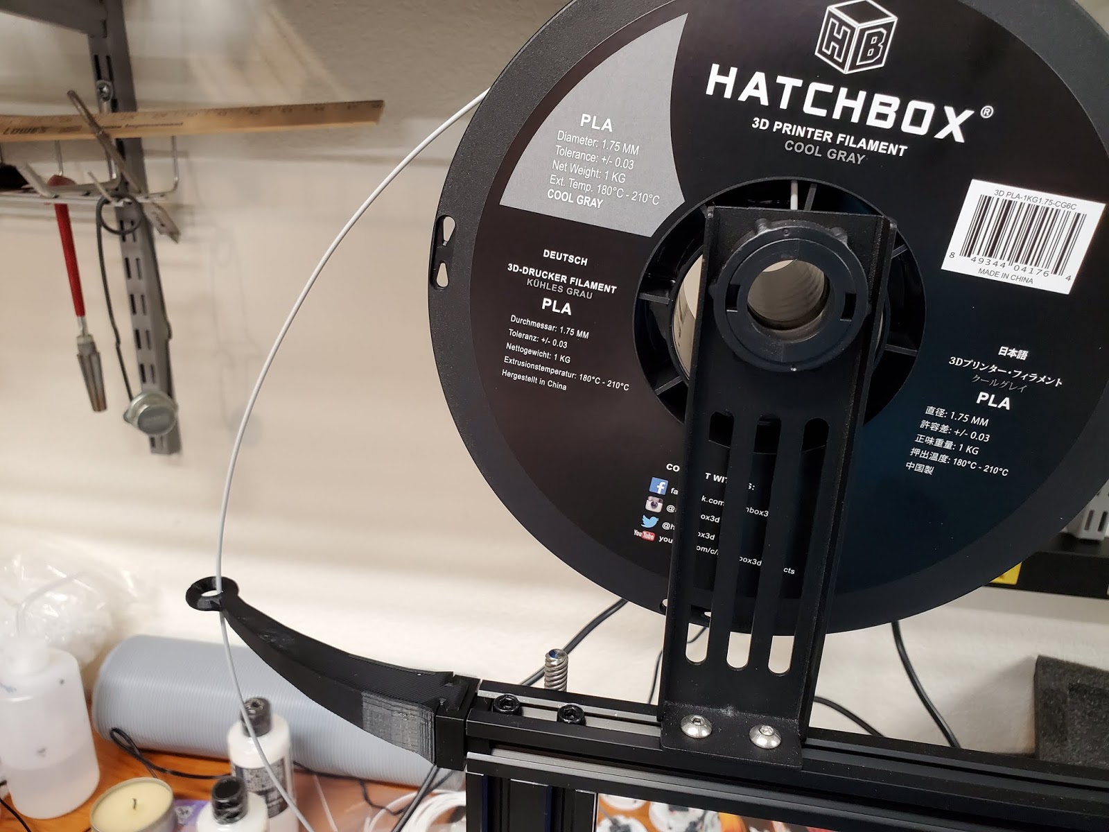
The filament guide seems to help with unspooling the filament so you are no longer pulling straight down.
I found this tool rack very helpful. As you can see, I'm sort of a slob. Now I can find all the tools when I need them. As long as I put them back in the organizer.
Lastly, I printed this filament guide. As you can see, I ran out of Black filament before printing it. Oh well. I printed it at 0.2mm, so that's why it may look a little rough. It's hard to see in the picture, but I did wear a groove in the plastic around where the filament goes into the feed. I din't see it until after I had switched to grey filament. Hopefully this guide will fix that so it doesn't continue to happen.
Hope this helps you if you're having trouble with your printing projects.
Thanks for looking and commenting.
Showing posts with label Worldographer. Show all posts
Thursday, April 9, 2020
Sunday, February 23, 2020
My Map Quest.
Hi All,
I know, this map thing.
Let's just refresh in our minds what we're talking about.
Here's the scan and rebuild of the Mighty Empires tile map that I made with my gaming buddy almost 30 years ago.
This was my hand drawn interpretation that I colored in. I made lots of xeroxes of the base map and we used it for a play by mail campaign.
As I have shown, many many times on this blog, I've been trying to input this into Worldographer and get a usable hex map that I can drill down into. So I did this.
This is just one section of the the whole map that I input into the program. You can see I'm using the trace underlay feature and doing 4 hexes to one from the paper map. My idea was to make a Kingdom level map, where each hex is about 6miles. One day of travel for a large army across wilderness. Actually 6 miles is a measurement from Adventure, Conqueror, King and it correlates fairly well with 5 mile breakdown from Charles S Grant's Wargame Campaigns. The problem is that the major cities were way too close together at this scale.
After faffing about with trying to copy this map into one up a layer of size, I gave up and bit the bullet. I decided to redo the map from scratch increasing the scale of my paper map hex by 4. So 16 6mile hexes instead of 4 per paper map hex.
I almost didn't do it, I have a long history of getting frustrated with making this map, but I let my stubbornness take over. Originally I had dreaded having to go back in, hex by hex for a 208 hex square map instead of the original 52. Then I realized there was a paint bucket function. Duh!
So, still a fair amount of work, but much quicker at the moment.
Not bad. I filled in all the Grassland and three colors of ocean. Just did it here and there when I had time during the week. The plan is to fill in all the basic terrain types. Plains, Forests, Hills, Mountains and then massage the individual hexes as I drill down into the individual political divisions.
I also finally started putting together my unit of Skaven Slaves. I'll post more on that another time.
Thanks for looking.
I know, this map thing.
Let's just refresh in our minds what we're talking about.
Here's the scan and rebuild of the Mighty Empires tile map that I made with my gaming buddy almost 30 years ago.
This was my hand drawn interpretation that I colored in. I made lots of xeroxes of the base map and we used it for a play by mail campaign.
As I have shown, many many times on this blog, I've been trying to input this into Worldographer and get a usable hex map that I can drill down into. So I did this.
This is just one section of the the whole map that I input into the program. You can see I'm using the trace underlay feature and doing 4 hexes to one from the paper map. My idea was to make a Kingdom level map, where each hex is about 6miles. One day of travel for a large army across wilderness. Actually 6 miles is a measurement from Adventure, Conqueror, King and it correlates fairly well with 5 mile breakdown from Charles S Grant's Wargame Campaigns. The problem is that the major cities were way too close together at this scale.
After faffing about with trying to copy this map into one up a layer of size, I gave up and bit the bullet. I decided to redo the map from scratch increasing the scale of my paper map hex by 4. So 16 6mile hexes instead of 4 per paper map hex.
I almost didn't do it, I have a long history of getting frustrated with making this map, but I let my stubbornness take over. Originally I had dreaded having to go back in, hex by hex for a 208 hex square map instead of the original 52. Then I realized there was a paint bucket function. Duh!
So, still a fair amount of work, but much quicker at the moment.
Not bad. I filled in all the Grassland and three colors of ocean. Just did it here and there when I had time during the week. The plan is to fill in all the basic terrain types. Plains, Forests, Hills, Mountains and then massage the individual hexes as I drill down into the individual political divisions.
I also finally started putting together my unit of Skaven Slaves. I'll post more on that another time.
Thanks for looking.
Wednesday, September 25, 2019
Back to map making and world building
Hi All,
We're back in the middle of Cross Country season and my daughter has started doing more extracurricular stuff as well, but is not quite ready to drive herself. So I somehow haven't had the time to sit down and blog.
Hobby stuff has been happening, but it's been a fair amount of noodling around with not much completed to show for it.
I thought I would share how my mapping of my old Mighty Empires campaign world has progressed. Like a lot of things in life, I find myself waffling about and abandoning and re-engaging in projects all the time.
Above is the map with reduced opacity so that I can trace the coastline and see where the terrain goes. Below is the opaque version which does a better job of hiding the polygons I'm using to trace the coast.
If you have been following my map saga, you may remember I have been struggling with how to scale the Mighty Empires map and make it part of a larger world map. I thought that Worldographer was the answer, and then ran into difficulties that I couldn't get my head around.
I then saw another software on Kickstarter that looked cool and plumped down a chunk of change for that. Of course now the bug was back and I reopened Worldographer and started noodling around with it. After a few calculations, and many failures, I think I figured out a scheme. I got on the forums and worked out a little of the things I needed to understand better to work around.
I am currently redoing the coastline, fixing which hexes are land and sea and then adding a polygon to make the coastline. My rule of thumb is the hex has to be at least half land for it to be a land hex. I then make either a land or a sea polygon to make the coast. I will probably adjust the shapes of the other terrain with polygons to make them less angular as I progress. I also need to adjust the terrain a little bit and play with the hex stats, such as elevation.
I ran the auto generated coast tool on it, but I am deleting most of those polygons so that I can match my original map.
Anyway, yadda yadda. Blah, blah.
Thanks for looking.
PS - Each hex is 6 miles, bath tubbing the size of Mighty Empires I think. I went with the convention of 4 sub hexes per large hex. So going up to the Region level will give me 24 mile hexes, Continent will be 96 miles, World 384 miles.
We're back in the middle of Cross Country season and my daughter has started doing more extracurricular stuff as well, but is not quite ready to drive herself. So I somehow haven't had the time to sit down and blog.
Hobby stuff has been happening, but it's been a fair amount of noodling around with not much completed to show for it.
I thought I would share how my mapping of my old Mighty Empires campaign world has progressed. Like a lot of things in life, I find myself waffling about and abandoning and re-engaging in projects all the time.
Above is the map with reduced opacity so that I can trace the coastline and see where the terrain goes. Below is the opaque version which does a better job of hiding the polygons I'm using to trace the coast.
If you have been following my map saga, you may remember I have been struggling with how to scale the Mighty Empires map and make it part of a larger world map. I thought that Worldographer was the answer, and then ran into difficulties that I couldn't get my head around.
I then saw another software on Kickstarter that looked cool and plumped down a chunk of change for that. Of course now the bug was back and I reopened Worldographer and started noodling around with it. After a few calculations, and many failures, I think I figured out a scheme. I got on the forums and worked out a little of the things I needed to understand better to work around.
I am currently redoing the coastline, fixing which hexes are land and sea and then adding a polygon to make the coastline. My rule of thumb is the hex has to be at least half land for it to be a land hex. I then make either a land or a sea polygon to make the coast. I will probably adjust the shapes of the other terrain with polygons to make them less angular as I progress. I also need to adjust the terrain a little bit and play with the hex stats, such as elevation.
I ran the auto generated coast tool on it, but I am deleting most of those polygons so that I can match my original map.
Anyway, yadda yadda. Blah, blah.
Thanks for looking.
PS - Each hex is 6 miles, bath tubbing the size of Mighty Empires I think. I went with the convention of 4 sub hexes per large hex. So going up to the Region level will give me 24 mile hexes, Continent will be 96 miles, World 384 miles.
Subscribe to:
Posts (Atom)


