Hi All,
I've had a few things going on, but not a lot of time for the blog. After the school year ended for us, Aidan and I went to Kublacon and had a good time. At some point I'll do a overview report of that.
I'm still sitting on our last local game of MESBG for a video/comic report and I intend to do some for the games we played at Kublacon. I'm a tad behind on doing track photos and band photos, but I should have more time soon.
In between honey do projects for my in-laws I've gotten back to working on my map.
It turns out I've gone back to some tutorials I found years ago and tried some things out.
First I roughly followed this PDF to make a height field in Photoshop. You could just use it to make the map and be done. I, of course, made things more complicated.
Here is my completed heightfield. It took me three iterations.
I then tried to follow a tutorial for running this height map through Wilbur and it took me several tries before I understood what exactly was going on with the software. For one thing my image is 7200 x 5400 and that puts a lot of stress on my Surface Tablet when running things in Wilbur. Particularly Incise Flow Erosion. That aforementioned PDF talks about how to process the image through Wilbur, but I found a more in detail one that helps with placing rivers and lakes where you want them, here.
In it they discuss making masks and there is a very detailed PDF link included for the Wilbur operations used.
This is the Height Map I exported from Wilbur.
Some of my forced river valleys are a tad clunky, but you get the overall concept.
I've then been trying to work out how to use Toby Rawal's process from this video.
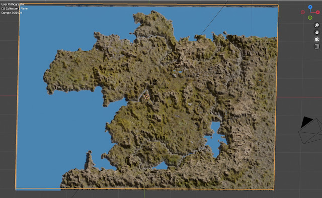
This is what I have so far.
Obviously a lot of work left to do. I mostly spent time setting up the Node tree to get all of my Textures and mixes in, but the mix is acting a tad bizarre. I don't totally care for my water at the moment and The sand should obviously only be on the shore line.
I've also played around with Terresculptor, but I haven't learned how to use it well yet. It does look promising though.
You can get the latest version of Wilbur (1.92 I think) here. Supposedly if you have Fracterra from Profantasy that is the commercial version of Wilbur.
Anyway, I hope you are living your best hobby life. Let me know if you have questions or want to share how you make maps.
Cheers.


.png)